Airport Mapping Database (AMDB)
Use cases, layer information, and API details for Navigraph's Airport Mapping Database
Navigraph provides an extensive dataset of airport layout geometries known as the Airport Mapping DataBase, or AMDB. The AMDB contains information and geometry for key airport features such as terminals, taxiways, stands, hotspots, holding points, and many more.
Use Cases
Airport Maps
Airport Maps are systems on aircraft which render a map of the airport onto the aircrafts navigation display to aid pilots in finding their way around airports. See the Flybywire A380 OANS or the Inibuilds A350 ANF.
Brake to Vacate (BTV)
Brake to Vacate (BTV) is a system on aircraft which allows pilots to select the runway intersection at which they wish to leave, allowing the aircraft to automatically apply the neccessary braking to bring the aircraft to the correct speed by that intersection.
Taxiway Routing
The Aerodrome Surface Routing Network (ASRN) can be fed into pathfinding algorithms to allow automatic path generation between two points in the airport. Metadata associated with the network elements can be used to generate plaintext instructions from the paths, or to generate the paths from plaintext.
Takeoff Performance
The locations of runway intersections can be determined using Runway Exit Line nodes, and connecting taxiways found to provide a list of intersections and their associated run distances for the purposes of takeoff performance selection.
Layers/Features
The Airport Mapping Database is made up of Layers, with the entries in each layer being known as Features. The types of layers available are indicated by the feattype enum, with all features in a given layer sharing the same feattype property. Each feature has a geometry which may be a Polygon, Linestring, or Point.
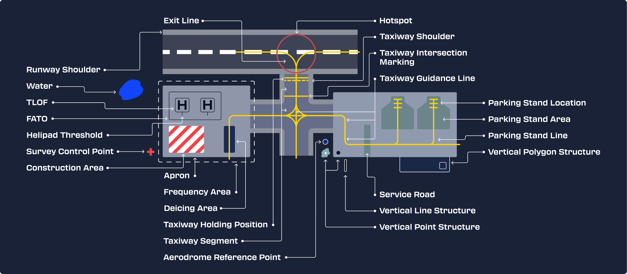
See the pages in the Layers folder for documentation about each different layer (note that the AsrnNode layer has multiple pages as it has subtypes), as well as an airport sample where the features from the given layer are highlighted blue and interactive. See enums for information about the enumerated types used for layer properties.
API/Data loading
AMDB data is served through an API, where you may request the data for given layers at a given airport. There are two geometry projections available:
- EPSG:4326 - Standard global degree based latitude/longitude system
- Airport Azimuthal Equidistant - Coordinate system centered around the aerodrome reference point with units in meters. Useful for close up map rendering to reduce projection load on client
The data formats available are geojson or PBF.
To determine if the AMDB covers a given airport, you can either query the Aerodrome Reference Point Layer as every airport is guaranteed to have an entry, or use the Search Endpoint. There are two endpoints available for querying data.
- Get Layer - Used for querying a single layer, which returns a geojson Feature Collection for that layer
- Get Layers - Used for querying multiple layers at once, which returns an object mapping the layer names to the geojson Feature Collection for that layer
We do not allow bundling the complete AMDB dataset in the end user software. Scraping the API to generate one yourself would be a violation of our Terms of Service.
Chart Type Codes
The `type_code` field provides fine-grained chart classification beyond the basic category. This can be used to facilitate more specific filtering of charts. Type codes also indicate whether an approach chart is a precision approach.
Get Cycle GET
Returns information about the current database cycle